MAPS

GOOGLE EARTH FILES
Download these files to view old growth on your computer using Google Earth
.KMZ
.KML
Based on 2019 data from BC Data Catalogue

Shows:
Old Growth (all old growth, big tree old growth and ancient old growth)
Parks, OGMAs and no harvest Wildlife Habitat Areas (to see which stands had some level of protection as of 2019)
WFP's Stillwater Operational Information Map, showing cutblock and road status, and current OGMAs as of May 2021
LEGEND
Bright Green All old growth (>250yo)
Dark Green Ancient old growth (>300 yo)
Turquoise Big tree old growth
Pink OGMA - Old Growth Management Area
Purple Wildlife Habitat Area (no harvest)

Best viewed with Adobe Acrobat Reader DC, so layers can be turned on and off.
Shows:
Big Tree Old Growth (250 yrs + site index >20)
All Old Growth (>250 yrs )
Parks, OGMAs** and no harvest Wildlife Habitat Areas (to see which stands had some level of protection as of 2019)
Western Forest Products Stillwater Operational Map (May 2021)
Parks, OGMAs** and no harvest Wildlife Habitat Areas (to see which stands had some level of protection as of 2019)
**(note that OGMAs are sometimes moved around by the licensee - these maps should be cross–checked against current operational maps)
INTERACTIVE GeoPDF FILES
HIGH RESOLUTION (Very large file sizes 60-80MB) High resolution PDFs are suitable for viewing on your computer. They are georeferenced and interactive if viewed with Adobe Acrobat Reader DC, allowing the map layers to be turned on and off, and viewing of the information about the polygons that comprise each layer - click on icons on the lefthand sidebar to open up menu options.
LOW RESOLUTION These PDFs are georeferenced. Download them into your Avenza app to find old growth patches using your device in the field. These files can also be viewed with any PDF reader, however, if viewed with Adobe Acrobat Reader DC, the map layers can be turned on and off, and information about the polygons that comprise each layer can also be viewed - click on icons on the lefthand sidebar to open up menu options.
**All maps based on 2019 data from BC Data Catalogue


Shows:
Big Tree Old Growth
(250 yrs + site index >20)
All Old Growth
(>250 yrs)


Shows:
Big Tree Old Growth (250 yrs + site index >20)
All Old Growth (>250 yrs )
Parks, OGMAs** and no harvest Wildlife Habitat Areas (to see which stands had some level of protection as of 2019)
**(note that OGMAs are sometimes moved around by the licensee - these maps should be cross–checked against current operational maps)
Old Growth Deferral Announcement November 2, 2021
The Government of British Columbia announced their Old Growth deferrals – mapped and defined by a panel of independent scientific and ecological experts. They have been shared with First Nations rights and title holders so they can advise how to proceed on the deferral areas within their respective territories.

qathet Old Growth (qOG) believes that ancient forests in our Regional District have not been identified.
qathet Old Growth was pleased to hear the BC Government’s November 2nd announcement on its intent to pursue "priority deferral" of 2.6 million hectares of old growth forest. It is also pleased with the release of the Old Growth Technical Advisory Panel's report on priority deferrals and associated maps.
While qOG applauds many aspects of the Technical Advisory Panel’s (TAP) report and mapping, we have significant concerns regarding their Map 4: Ancient Forest (depicted for qathet Regional District in Figure 1), and how this mapping skews their proposed priority harvest deferral areas (depicted for qathet Regional District in Figure 2). Priority harvest deferral areas were derived by combining TAP’s Prioritized Big-tree Old Growth (Map 3), Remnant Old Ecosystems (Map 4) and Ancient Forests (Map 5) (to view, refer to this interactive website).
Our concerns relate to inherent deficiencies in the Provincial Vegetation Resource Inventory (VRI), whereby age class data does not discriminate between old (250+ yo) and ancient (400+ yo) forests, and ages assigned to old growth stands are unreliable and often underestimated (therefore requiring on the ground identification using tree core analysis). Our review of the spatial data for qathet Regional District (qRD) indicates that these deficiencies have likely resulted in a significant underestimation of extent of ancient forest occurring in qRD, with far fewer priority deferral areas (Figure 2) being identified by TAP as a result.
1 According to the Old Growth Strategic Review, ancient (400+ year old) forests have ancient genetic material and are repositories of biota and processes we may not even know or understand. This makes them an extremely important buffer against species extinction, climate change, and lost future opportunities. These “ancient forests” are globally unique, rare, and contain species as yet undiscovered, and many of these ecosystems and old forests are non-renewable within any reasonable time frame. Many of these irreplaceable forests are in the timber harvesting land base and are subject to logging,
2 Holt R., Price, K., Kremsater, L., MacKinnon, A., and K. Lertzman (2008). Defining old growth and recovering old growth on the coast: discussion of options.
3 Report prepared for the Ecosystem Based Management Working Group .
4 Old Growth Technical Advisory Panel (2021). Priority Deferral Areas: An Ecological Approach.
For reasons outlined in Box 1 below, we believe that Figure 3 is a more accurate representation of the likely extent of ancient forest in the qRD, and that these areas should be included in TAP’s priority deferral areas mapping (as illustrated in Figure 4), unless otherwise ruled out by groundtruthing via tree core analysis.
-

Technical Advisory Panel mapping showing only a handful of of ancient forest stands (400+ years old) in qathet Regional District.
-

Priority old growth deferral areas for qathet Regional District, as mapped by the Technical Advisory Panel, based in part on the ancient forest mapping shown in Figure 1.
-

qOG’s estimation of a more likely extent of ancient forest in qathet Regional District, as per reasons outlined in Box 1 below.
In qRD the stakes are high in this regard, as most old growth logging is currently taking place in higher elevation remnant forests that are more likely to be ancient (most of the lower elevation, easily accessed forest having already been logged). This is exemplified by the Freda Ancient Forest Cutblock Report which documents trees between 800 and 1200 years old felled in a recent WFP cutblock on Mount Freda; the VRI assigned age for this stand was 351 years (also see attached Powell River Living article);
Figure 5 shows that a number of old growth stands within proposed Western Forest Products (WFP) cutblocks fall outside TAP’s currently proposed priority deferral areas. qOG believes there is a significant probability that these stands are actually ancient, and that at a minimum groundtruthing of the ages of these stands is urgently required. Similar cutblocks proposed by other licensees require the same treatment.
qOG respectfully asks for these concerns about underrepresentation and mislabelling of ancient forests prior to finalizing priority deferral areas for qRD, and provide the public and First Nations with a methodology detailing how this will be done given the absence of reliable spatial data. We ask that you use the precautionary application of surrogate data (such as we did in generating Figure 2), and comprehensive groundtruthing via tree core analysis.
-
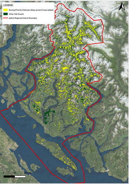
qOG’s estimation where priority deferral areas should be located, to better incorporate stands which are likely to be ancient, but which are not captured as such in Provincial databases.
-

Old growth that falls within proposed WFP cutblocks and also falls outside the Technical Advisory Panel’s proposed priority deferral areas. Stands shown in bright green have a significant likelihood of being ancient, despite not being mapped as such.
-

Trees between 800 and 1200 years old felled in a recent WFP cutblock on Mount Freda; the VRI assigned age for this stand was 351 years.
-
Box 1. Reasons for concern about TAP’s ancient forest and priority deferral area mapping in qathet Regional District:
1. In qathet Regional District, most of the remaining Big Tree Old Growth) is located in wetter and higher elevation areas (i.e. the CWHvm and MHmm biogeoclimatic subzones) due to extensive historic logging in lower elevations, coastal areas, and along valley bottoms.
2. Because wetter and higher elevation coastal forests naturally experience only low levels of disturbance (e.g. fire), historically these forests would have been 85-95% old growth (as per Table 1 in our March 2021 report to the Minister). Fire-return intervals in these types of forests have been estimated at between 700 and 6000 years1, and as a result some forests are many thousands of years old2. For example, the Caren Range Forest of the lower Sunshine Coast is known to have 1250 year old Hemlock and 1824 Yellow Cedar, and may be the oldest known closed canopy forest in the world3.
3. Consequently, in qRD the ages of many remaining big tree old growth stands in the CWHvm and MHmm BEC subzones of would be expected to be ancient (400+ years old), particularly those stands in the MHmm subzone, where trees are slow growing and small for their age (and hence are often many hundreds of years old before reaching a harvestable size). This is depicted by Figure 3, in which we highlight higher elevation big tree stands in the CWHvm and MHmm zones labelled as 300+ years old in the VRI, which we believe are likely to actually exceed 400 years of age.
4. In comparison, the Technical Advisory Panel’s mapping of ancient forest4 (Figure 1) shows only a handful of ancient forest stands in the qathet Regional District, with none being labelled as greater than 557 years old.
5. Empirically we know there are mislabelled ancient stands in qRD, including stands that are greater than 557 years old. Tree ring counts on a selection of stumps in a recent WFP cutblock in the MHmm zone of Mount Freda (in the qRD) found trees between 800 and 1200 years old (see attached report, and Powell River Living Figure 6). However, the VRI assigned age for the stand was only 351 years, illustrating the limitations of using existing provincial forest cover data to identify ancient forest attributes. We are certain many more ancient forest stands will be revealed by further groundtruthing efforts.
__________________
1 Lertzman, K., D. Gavin, D. Hallet, L. Brubaker, D. Lepofsky and R. Mathewes. 2002. Long-term fire regime estimated from soil charcoal in coastal temperate rainforests. Conservation Ecology 6 (2): 5. https://www.ecologyandsociety.org/vol6/iss2/art5/
2 Price, K., R.F. Holt and D. Daust (2020). BC’s Old Growth Forest: A Last Stand for Biodiversity.
3 Jones, P. (2003). Caren Range Ancient Forest. Paper submitted to the XKK World Forestry Congress, 2003, Quebec City, Canada. https://www.fao.org/3/XII/0081-B1.htm
4 Which was based on Province of BC 2010. BC Land Management Handbook #25. Structural stage 7b. NDT 1, 2 and 4 for less frequent disturbance.

Mount Freda is in the traditional territories of the Tla'amin and shíshálh Nations. They could possibly be some of the oldest forests in Canada and apart of the oldest living closed canopy forests in the world.